Grade 2 Social Studies

Glossary of Terms and Concepts for Grade 2 Social Studies

Acadia was an early French colony in North America. The French called it Acadie. It was part of what was known as New France. Acadia was located generally in the area that is now the provinces of Nova Scotia and New Brunswick in Canada. Acadia was founde

Grade 2 The following terms and concepts are contained within the general and specific outcomes in the grade. The definitions are provided to facilitate a better understanding and more effective application of the social studies concepts presented.

Acadians - Descendants of approximately 100 French families who settled along the shores of the Baie française (now the Bay of Fundy) in the area now known as New Brunswick, Nova Scotia and Prince Edward Island.

Cultural diversity - Differences in groups having a variety of languages, ethnicity, nationalities, within a shared space.

Goods - Items that are produced and have an economic value. human geography The branch of geography that pertains specifically to how humans adapt to their environment.

Inuit -A member of any of several Aboriginal peoples who live in coastal regions of the Canadian Arctic and in Greenland.

Physical geography -The study of the physical characteristics of the environment, for example, landforms, climate and bodies of water.

Rural -Relating to agricultural; or sparsely populated; of or relating to people who live in the country

Services - Physical or intellectual labour. Work done for someone else that improves quality of life.

Urban - Relating to cities or city life.

Eastern Coastal Canadian Community - Acadia

What is Acadia?

Acadia was an early French colony in North America. ... Acadia was located generally in the area that is now the provinces of Nova Scotia and New Brunswick in Canada. Acadia was founded when the French built a fort called Port Royal in 1605. It was located at the mouth of the Annapolis River in what is now Nova Scotia.

Acadia (French: Acadie) was a colony of New France in northeastern North America which included parts of eastern Quebec, the Maritime provinces, and Maine to the Kennebec River.

Acadia, French Acadie, North American Atlantic possessions of France in the 17th and 18th centuries. Centred in what are now New Brunswick, Nova Scotia, and Prince Edward Island, Acadia was probably intended to include parts of Maine (U.S.) and Quebec.

The Acadians (French: Acadiens) are the descendants of the French settlers, and sometimes the Indigenous peoples, of parts of Acadia (French: Acadie) in the northeastern region of North America comprising what is now the Canadian Maritime Provinces of New Brunswick, Nova Scotia and Prince Edward Island, Quebec and part of US. 

Do Acadians still exist?

The Acadians today live predominantly in the Canadian Maritime provinces, as well as parts of Quebec, Louisiana and Maine. ... Many Acadians still live in and around the area of Madawaska, Maine where the Acadians first landed and settled in what is now known as the St. John Valley.

Links:

https://thecanadianencyclopedia.ca/en/article/acadian-culture

https://school.eb.com/levels/elementary/search/articles?query=Acadia&includeLevelOne=false (see teacher for password)

http://online.culturegrams.com/provinces/province.php?pid=9 (see teacher for password)

Photo and Video Links

https://kids.nationalgeographic.com/explore/nature/acadia/

http://switchbackkids.com/acadia/

Maps of Acadia 

Related image

Image result for acadia mapsRelated imageRelated image

Sources:

https://kids.britannica.com/kids/article/Acadia/443550

www.britannica.com › place › Acadia

en.wikipedia.org › wiki › Acadia

https://celticlifeintl.com/acadia/


Northern Canadian Community - Nunavut

Flag of Nunavut.svg

Nunavut is a massive, sparsely populated territory of northern Canada, forming most of the Canadian Arctic Archipelago. Its islands have expanses of tundra, craggy mountains and remote villages, accessible only by plane or boat. It's known for its indigenous Inuit people's artwork, carvings and handmade clothing. Inuit art is displayed at the Nunatta Sunakkutaangit Museum in the capital, Iqaluit, on Baffin Island. Mainland Nunavut was first populated approximately 4500 years ago. The creation of Nunavut has been followed by considerable population growth in the capital Iqaluit, from 5,200 in 2001 to 6,600 in 2011, a 27% increase.

Capital: Iqaluit

Population: 38,780 (2019)

Inuit (84.7%)  European Canadian (11.6%)  Visible minority (2.5%)  First Nations (0.5%)  Métis (0.5%)  Other Indigenous (0.2%)

Languages: Along with the Inuit Language called Inuktitut 63%, English 32% and French 1% are also official languages.

Religions:  Anglican Church of Canada with 15,440 (58%); the Roman Catholic Church (Roman Catholic Diocese of Churchill-Hudson Bay) with 6,205 (23%); and Pentecostal with 1,175 (4%).[42] In total, 93% of the population were Christian.

Economy/Resources: The economy of Nunavut is driven by the Inuit and Territorial Government, mining (gold, copper, silver, zinc, lead, diamonds, uranium and iron ore), oil gas mineral exploration, arts crafts, hunting, fishing, whaling, tourism, transportation, housing development, military, research, and education. 

Energy: Nunavut's people rely primarily on diesel fuel to run generators and heat homes, with fossil fuel shipments from southern Canada by plane or boat because there are few to no roads or rail links to the region. There is a government effort to use more renewable energy sources,which is generally supported by the community.

This support comes from Nunavut feeling the effects of global warming. Former Nunavut Premier Eva Aariak said in 2011, "Climate change is very much upon us. It is affecting our hunters, the animals, the thinning of the ice is a big concern, as well as erosion from permafrost melting." The region is warming about twice as fast as the global average.

Sources:

https://en.wikipedia.org/wiki/Nunavut

https://www.gov.nu.ca/eia/information/nunavut-faqs

flag https://en.wikipedia.org/wiki/Flag_of_Nunavut

Prairie Communities of Canada - Alberta & Saskatchewan

Image result for canadian prairies  Image result for canadian prairiesImage result for canadian prairies

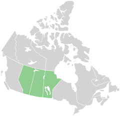
Prairies have similar temperate climates, moderate rainfall, and a composition of grasses, herbs, and shrubs, rather than trees, as the dominant vegetation type. The Canadian Prairies occupy vast areas of Manitoba, Saskatchewan, and Alberta.

Main climates:  The climate of the Canadian prairie region is defined as semi arid (partly dry), snowy, fully humid with cool summers, fully humid with warm summers, semi-cold and arid climate.

Precipitation (rain & snow) in the Canadian prairies are very important to study as these locations make up 80% of the country's agricultural(farming) production. Saskatchewan obtains the least amount of precipitation annually and Manitoba receiving the most. Most rainfall typically happens in the summer months such as June and July. With the high humidity of the prairies, tornadoes are likely to occur due to the relatively flat surface of the region.

Population:

Rank Census metropolitan area Population (2011) Population (2006) Province
1 Calgary 1,214,839 1,079,310 Alberta
2 Edmonton 1,159,869 1,034,945 Alberta
3 Winnipeg 730,018 694,668 Manitoba
4 Saskatoon 260,600 233,923 Saskatchewan
5 Regina 210,556 194,971 Saskatchewan

Growth: Some of the prairie region of Canada has seen rapid growth from a boom in oil . The prairie provinces had grown by 14.6% to 6,748,280.

Culture and politics:  The Prairies are distinguished from the rest of Canada by cultural and political traits. The oldest influence on Prairie culture are the First Nations, who have lived in the area for millennia. The first Europeans to see the Prairies were fur traders and explorers from eastern Canada (mainly present-day Quebec) and Great Britain via Hudson Bay. They gave rise to the Métis, working class "children of the fur trade."[5] During their settlement by Europeans, the prairies were settled in distinct ethnic block settlements giving certain areas distinctively Ukrainian, German, French, or Scandinavian Canadian cultures.

Economy/resources:

Between 1670 and 1870, the Hudson’s Bay Company was granted exclusive fur trading rights to the area drained by the rivers flowing into Hudson Bay, then called Rupert's Land.

American bison k5680-1.jpg bison 

The earliest significant human modification of the native prairie ecosystems was spurred by European demand for products of the fur trade, particularly those from bison. The killing of thousands of bison each year by European settlers led to the virtual elimination of free-roaming bison by the 1880s.

Hudson Bay - Map of Hudson BayHudson's Bay Area

Railways played a leading role in defining the pattern of development. Towns emerged along the rail line as collection points for grain and livestock exports and as distribution points for incoming supplies. By 1916, Canada was leading the world in wheat exports. Twenty-five years later, 60% of the Prairies Ecozone was under cultivation and the landscape resembled a checkerboard.

In 1936, farmers represented 50% of the population. Today that number has fallen to less than 10%. Population decline in the rural areas and growth in the urban areas has been the general rule since the 1950s. Although urban use of land is tiny in terms of area (0.3%), it remains an important influence on the ecozone. Today, the proportion of the urban population is 81% compared with 76% for all of Canada, a remarkable figure given that agricultural activities dominate the landscape of this ecozone. In 1991, the total population of the Prairies Ecozone was approximately 3.8 million, an increase of 25% since 1971. The major population centres are Calgary, Edmonton, Saskatoon, Regina and Winnipeg.

The economy of the prairies include industries of agriculture, mining, and gas and oil. The Prairies provide 19% of Canada's total resource-based employment, with agricultural activities and food processing accounting for nearly 62% of the total. Its minerals industry (fossil fuels and related products) accounts for nearly a third of Canada's total employment in this sector. 

The Prairies farm a variety of crops such as grain, canola, beef, dairy, pigs, horses, chickens, and turkeys. 

Mining is the second most important industry. In Saskatchewan, mines include potash, uranium, coal, gold, salt, meta-kaolin, silica sand, sodium sulphate, clay and bentonite. In Alberta, mines include oil sands; coal; limestone; salt; shale; dimension stone; ammonite shell; sandstone; sand and gravel. Land use for oil production has declined over the past decade.

The Prairie economy is now shifting toward service-based sectors such as processing food, wood, metals, chemicals, and petrochemicals which are chemical made from petroleum and natural gas. Petroleum is a liquid mixture of hydrocarbons that is present in certain rock strata and can be extracted and refined to produce fuels including gasoline, kerosene, and diesel oil.

Videos:

What is a Prairie

Prairie Tall Grass

History of the Canadian Prairies 

Beauty of the Prairies

Sources: 

https://en.wikipedia.org/wiki/Canadian_Prairies

https://www.nrcan.gc.ca/environment/resources/publications/impacts-adaptation/reports/assessments/2008/ch7/10381

http://ecozones.ca/english/zone/Prairies/human.html

Websites:

https://thecanadaguide.com/places/the-prairies/

https://www.roughguides.com/destinations/north-america/canada/prairie-provinces/

https://www.britannica.com/place/Prairie-Provinces

https://www.arcgis.com/apps/MapJournal/index.html?appid=03401e1560e14ffea990099d89852d90

https://www.nrcan.gc.ca/environment/resources/publications/impacts-adaptation/reports/assessments/2008/ch7/10381

http://ecozones.ca/english/zone/Prairies/human.html

What is a Community?

community is a group of people living or working together in the same area. ... They are a type of community because they usually live together and do a lot of the same things. Then there are your friends. They share your ideas and probably go to the same school. Your neighborhood is a community.

There are three main types of communities; urban, suburban and rural.

An urban community is crowded with many people in a small area. A big city is an urban community. Neighbourhoods within big cities are also urban communities. Cities often have tall buildings to provide housing and workplaces for many people.

A suburban community is often called a suburb. It is located near a big city. Suburbs are less crowded than cities because they have fewer people living on larger areas of land. Suburbs may be towns, villages, or small cities. They typically have their own government, fire department, and school system. Often people who live in suburbs commute (or travel for work) to the city.

A rural community is sometimes called the country or the countryside. It has much fewer people living in a much larger area, so its homes and buildings are spread far apart. Much of the land in rural areas is used for agriculture, or farming.

Videos:

What is a community?

Types of communities

Community Helpers

What makes a good community?

Our Community:

City of St.Albert Website https://stalbert.ca/

Images of St.Albert(Suburban)

City of Edmonton Website https://www.edmonton.ca/

Images of Edmonton(Urban)

Rural Community Images